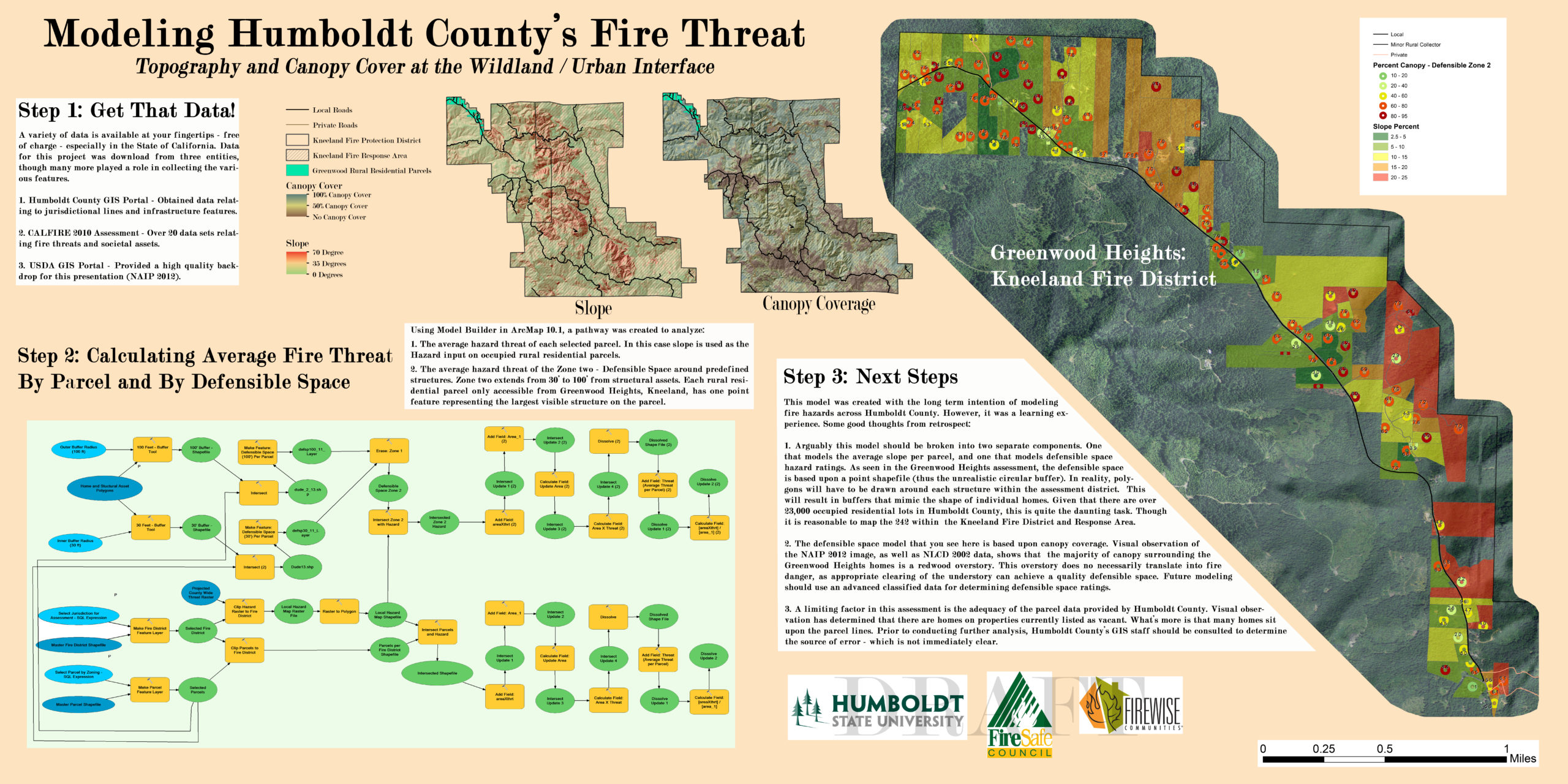
As an academic modeling and poster project, I used ArcMap’s Model Builder to assess the risk of fire to homes at both the parcel- and structural-level. To function, the model requires four geospatial inputs: (1) home and structural assets shapefile; (2) parcel shapefile; (3) fire district (or other jurisdiction boundaries) shapefile; and, (4) fire threat raster file (e.g., slope or canopy coverage).
In assessing risk at the structural-level, the model evaluates the defensible space of a home on the basis of canopy coverage within 30′ to 100′ from the home (defensible space, zone 2). This risk does not account for treatment of the understory; however, where the defensible space zone has a high risk value, homeowners should insure that the land is being managed to reduce that risk. Point files were used in the creation of this poster, thought I later created a fire district-wide structural polygon file using Google Earth. As designed, a polygon-shapefile that portrays the exterior extent of a structure should be input for the most accurate assessment of zone 2 hazard threats.
Parcel-levelrisk is assessed on the basis of the average slope of each parcel. The risk posed by slope is not necessarily borne by the structure on a parcel. Because hill slope creates higher risk of fire on structures located to the upside, neighboring parcels may suffer the greater risk of a neighbor’s sloped parcel. Also note that where rural parcels are very large, the actual risk to a particular structure may be more or less significant than shown by the output modeled here. This particular shortcoming could be addressed through interpolation methods in ArcMap.
In 2015, the Humboldt County Fire Safe Council requested assistance from the Humboldt State University Environmental Management and Protection Program Planning Practicum with a Firewise mapping project and with community organizing…
Poster Presentation
Intermediate GIS, Final Poster Project, Workflow Development (2014)
In 2015, the Humboldt County Fire Safe Council requested assistance from the Humboldt State University Environmental Management and Protection Program Planning…
Urban-Wildland Transect Design
Design Tutorial
This page provides tips for designing a wildland-urban transect using GIS, primarily for the purpose...
Race and Property Law in Los Angeles from 1892 to 1948
Legal Research
This project involved research into the development of caselaw on racially restrictive covenants (RRCs) in Los...
Mapping De Facto Segregation
Historic Landuse Analysis
Prior to taking on the official research assistant position, I volunteered to produce maps in...
The Front Range at Golden, Colorado
Relief Map
This topographic map was designed for the purpose of showing off the mesas and hogbacks...
Von Damien’s Land (RPG)
Design Tutorial
Fantasy map and role playing game (RPG) based on the skull of Alexander Pearce. Includes...
Urban-Wildland Transect Design
Design Tutorial
This page provides tips for designing a wildland-urban transect using...
Race and Property Law in Los Angeles from 1892 to 1948
Legal Research
This project involved research into the development of caselaw on...
Mapping De Facto Segregation
Historic Landuse Analysis
Prior to taking on the official research assistant position, I...
The Front Range at Golden, Colorado
Relief Map
This topographic map was designed for the purpose of showing...
Von Damien’s Land (RPG)
Design Tutorial
Fantasy map and role playing game (RPG) based on the...
Classroom to the Capitol
Lobby Leave-Behind
I served in multiple executive officer positions with the Associated...
Controversial Whaling Map for Gamers
Advocacy Map
As is so often the case, two competing views can...
Animated Water Use by California County
First-Last Animated Map
Initially, I prepared a large amount of data (for GIS)...
Precipitation in California: 1950 to 2014
Visualizing Climate
This time series required the acquisition of 61 years of...
Student Origins Illustrated
Diversity Map
Humboldt State University (HSU) is the most geographically isolated campus...
Urban Wildlife Interactions in Arcata, California
Survey & Scientific Report
The area where residential development is located proximate to wildland...
Impervious Surface at Lake Tahoe
Relief Map
I mapped impervious surfaces in alarming colors to call attention...